10,000 Year Old Stonehenge Monument
WRITTEN BY Austin Kinsley ON 20/02/15. 10,000 Year Old Stonehenge Monument POSTED IN Stonehenge
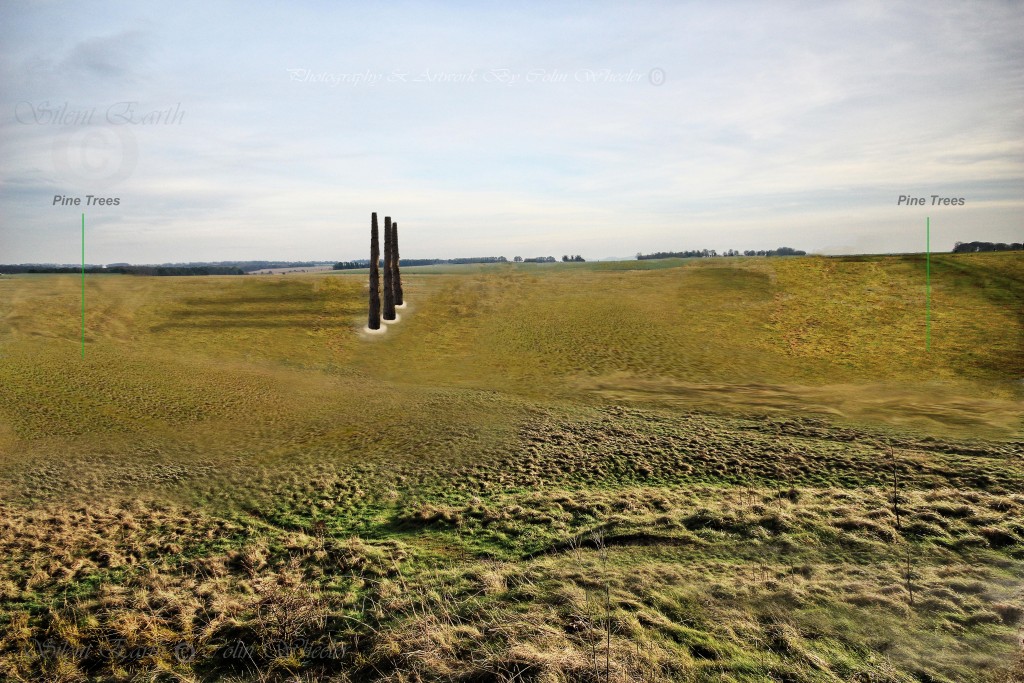
Man has enjoyed a close relationship with the landscape in the environs of Stonehenge since Mesolithic times and the first Stonehenge monument was erected 10 000 years ago of pine posts . By the time the ditch and bank structure that surrounds the monument that we are all familiar with today was constructed around 3,000 BC, that first monumentalised relationship with the area had existed for 5,000 years. Stonehenge has therefore been many ‘buildings’ over countless generations. Wooden posts and later stones have been frequently dismantled, moved, re-erected, added to and subtracted from. It is not beyond the realm of possibility that smaller-roofed structures may have existed over the millennia, as enigmatic post holes also exist within the monument site and these structures at times may have been roofed.
English Heritage state that “The earliest structures known in the immediate area are four or five pits, three of which appear to have held large pine ‘totem-pole like’ posts erected in the Mesolithic period, between 8,500 and 7,000 BC. It is not known how these posts relate to the later monument of Stonehenge.”
At that time, less than two miles to the east, close to the banks of the River Avon at Amesbury at ‘the cradle of Stonehenge’, the builders of that early monument feasted on aurochs, eel, salmon, trout, wild boar, red deer, hazelnuts and frogs’ legs.
In a conversation with Dan Rendell recently, he stated: “A recent theory put forward is that the ‘totem poles’ may have marked seasonal migrational routes of those aurochs, placed as a locator to hunters, and a ‘monument’ to those great beasts (auroch skulls were also found in the later henge ditch) which would have represented awesome adversaries, needing many men to take them down. They face up from the valley bottom, towards Amesbury’s “mother mound” hill (Vespasian’s Camp) which, like Silbury, is located on a site with a spring, and which produces magenta coloured flints. We also have to factor in Dave Field’s Mesolithic mound at the southwest quadrant of Stonehenge. Charcoal deposits possibly date this back to 8,000 BC. The remains of this mound can still be distinguished today, albeit largely eroded.”
At running speeds of up to 35 miles per hour, aurochs were surely awesome adversaries in Mesolithic times 10,000 years ago. Providing food for up to 100 people, a successful hunt would have been greatly rewarded. They may too have been venerated, representing the most powerful creature in the early Stonehenge landscape. The prehistoric Harrow Way running just south of Stonehenge may also have initially become established from earlier animal migration routes.
Between 7th and 18th March 1966, on behalf of the Ministry of Public Buildings and Works, Lance and Faith Vatcher excavated three post holes during an extension to the visitor car park at Stonehenge. Their original report, published in The Wiltshire Archaeological and Natural History Magazine in 1973, is here. Reports of the subsequent radiocarbon dates can be found in Radiocarbon volume 29. There is also a comprehensive synthesis on pages 42 to 56 in Stonehenge in its Landscape: Twentieth Century Excavations (SIIL) by R.M.J. Cleal et al. here . This also includes a summary of the Wessex Archaeology investigations of 1988 during the alteration and construction of visitor facilities in the car park when a possible fourth post hole was discovered northeast of the three discovered by the Vatchers in 1966, referred to in SIIL as WA 9580.
Chalkland:An Archaeology of Stonehenge and Its Region by Andrew J. Lawson, Hobnob Press, published 2007 states:
“In 1935 a car park was created to the north of the A344 road from Amesbury to Devizes, some 100m northwest of Stonehenge, so that visitors’ cars would not hinder traffic. Although the area stripped of turf and soil was examined by W. E. V. Young, an experienced excavator who had helped to supervise excavations by Alexander Keiller at Avebury, no features were found. The car park was later doubled in size but there is no record of archaeological work at that time. However, in 1966 when it was again extended (so that it was by this time four times the size of the original), a series of circular features cut into the chalk bedrock, and set roughly in line, were observed. Excavation was undertaken by Faith Vatcher, at that time the much-respected curator of the Avebury Museum, with her husband Major Lance Vatcher. They discovered that three of the features were substantial pits cut into the ground, while a fourth was the place where a tree had once stood. Whereas tree-throws are commonly found on the chalk of this area, the pits were more unusual. There is no record of whether the area where the new visitor facilities were to be placed was investigated by the Vatchers. However, when these facilities were also enlarged in 1988, a fourth pit was discovered. It was excavated and recorded by Martin Trott, a young graduate of Southampton University who at the time was working for Wessex Archaeology (later he joined the Inland Revenue.)
“The four pits were all roughly circular, 1.3m to 1.9m in diameter, and 1.3m to 1.5m deep, and appear once to have held substantial posts c.0.75m in diameter. Unlike the Vatcher’s pits, Trott’s was found to have been re-cut at a much later stage and subsequently deliberately back-filled. Only a few undiagnostic flint flakes and other remains were incorporated into the fill of the pits. However, charcoal from the fills was found to be solely from pine trees. More surprisingly, radiocarbon dates obtained from this charcoal suggest that the pits had been dug between 10,500 and 8,500 years ago. Snail shells and pollen grains preserved in the fill suggest that the pits were cut in woodland. Taken together, the disposition of soil layers within the pits, the pine charcoal, radiocarbon dates and snail shells provide sound evidence that during the Early Mesolithic a group of people erected stout pine posts in the middle of a mature pine and hazel (Boreal) woodland (Cleal et al. 1995, 43-56).
“Although Mesolithic sites sometimes produce evidence for light structures, such as shelters or huts, the nature of the features in the Stonehenge Car Park was without parallel. The original number of posts and the form of setting they created, or indeed whether they all stood at one time, is unknown because their discovery was fortuitous and the area investigated around them was limited. Similarly, their function is unknown. In the absence of better clues, it is tempting to suggest that they were erected for some special, ceremonial purpose, or to mark the land in a territorial way. The life-style of Northwest Coast Americans and their usage of large poles carved or hung with emblems and totems indicate the sort of tradition which might be envisaged. Nonetheless, the posts may well have marked an exceptional place whose meaning is now lost but which endured both while the posts stood and later. If, as seems likely, they stood in a primeval wood, or possibly a natural glade, their physical setting would have been very different from that of today.”
The car park post holes are also discussed:
On the Megalithic Portal here.
The Modern Antiquarian here.
The modern understanding of Stonehenge in its overall context is summarised with links here by Mike Pitts on his Digging Deeper blog.
What is known of the post holes and surrounding area?
- The posts in pits A, B and C were approximately 0.75 metres in diameter.
- The pits’ diameters and depths were A: 1.93 m by 1.34 m; B: 1.47m by 1-27m; C: 1.77m by 1.55m, respectively and at maximum diameter.
- The posts rotted ‘in situ’, leaving post shadows.
- Pit C did not exhibit such clear evidence of a postpipe, and the post may have been removed as the timber was rotting, causing minor disturbance.
- Carefully positioned wedges appearing to be of wood were reported in pits B and C.
- Decayed wood was also found in pits B and C, and possibly A.
- Charcoal was found in pits A, B and C.
- A fragment of burnt bone was found in pit B.
- Pine charcoal in pit A HAR-455 dates 8800-7790BC.
- Pine charcoal in pit B HAR-456 dates 7490-6640BC.
- The fourth excavated pit (Vatchers 1966) west of pit A and referred to as the ‘Tree hole’ was shallower at 0.7m in depth and 2.5 m in diameter, irregular in plan, and did not contain a postpipe characteristic. The age of this pit is unknown, and it is unknown whether there is any connection with pits A, B and C.

Mesolithic Post Holes Stonehenge Location Copyright English Heritage
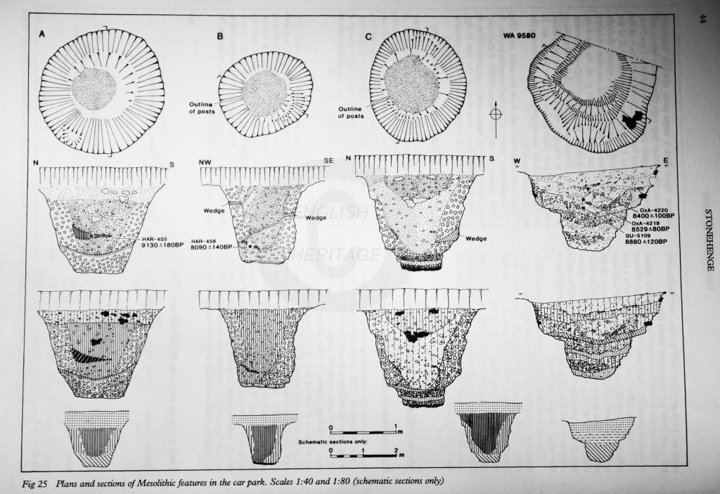
Mesolithic Post Holes Stonehenge Cross Section Copyright English Heritage
- In 1988 Wessex Archaeology investigated an additional area to the northeast of pits A, B and C above during alterations to visitor facilities by English Heritage. Martin Trott reported the discovery of a single additional pit known as WA 9580. The pit was 1.9 m in diameter and 1.3 m deep. At 1m the diameter reduced to 1m corresponding with a layer of compact, redeposited chalk (context 9587). The shape of the feature and fills suggest it was recut and modified, enlarging the upper profile of the pit. English heritage state “It is likely that this feature was originally dug as a postpit and was therefore similar to the other features in the car park. However, unlike the other postpits, in which the timbers rotted ‘in situ’ (Pits A and B, or from which a rotted post was removed pit C), this feature was partially backfilled, altered and redesigned as a broad shallow pit. One possibility is that it was simply decided to remove a post erected in this hole and that it was necessary to enlarge the pit in order to free it, and that it was then partially backfilled, creating the recut.” 14 soil samples were taken through the layers of backfilled coarse chalk rubble and the recut. The soil sample results are reported and interpreted in detail on pages 47-55 of Stonehenge in its Landscape. A piece of ryolite (bluestone) was found in the upper tertiary fill (uppermost layer) of this pit which is considered to be contemporary with phase 3 of Stonehenge itself (2550-1600BC). English Heritage conclude in SIIL that “at the time of construction of the pit the local environment was one of open woodland.’ The summary discussion on page 55 states that ‘The features discussed here were dug in the early Mesolithic (8500-7650 cal BC) in an open mixed pine and hazel woodland which it is assumed was cleared locally prior to and perhaps for this activity. The open nature of this woodland is indicated by the presence of hazel, one of its main constituents, which requires sunlight in order to flower, and also by the composition of mollusc assemblages. Local clearance is reflected in the assemblages (both pollen and molluscs) in the base of the recut shallow pit. The clearance within this woodland for the excavation must have been large enough to enable new mollusc fauna to start to become established. This indicates that there was open country in the vicinity from which this fauna originated and it seems that the open nature of the woodland itself would have provided such habitats…Nowhere in this sequence is the later Mesolithic represented.”
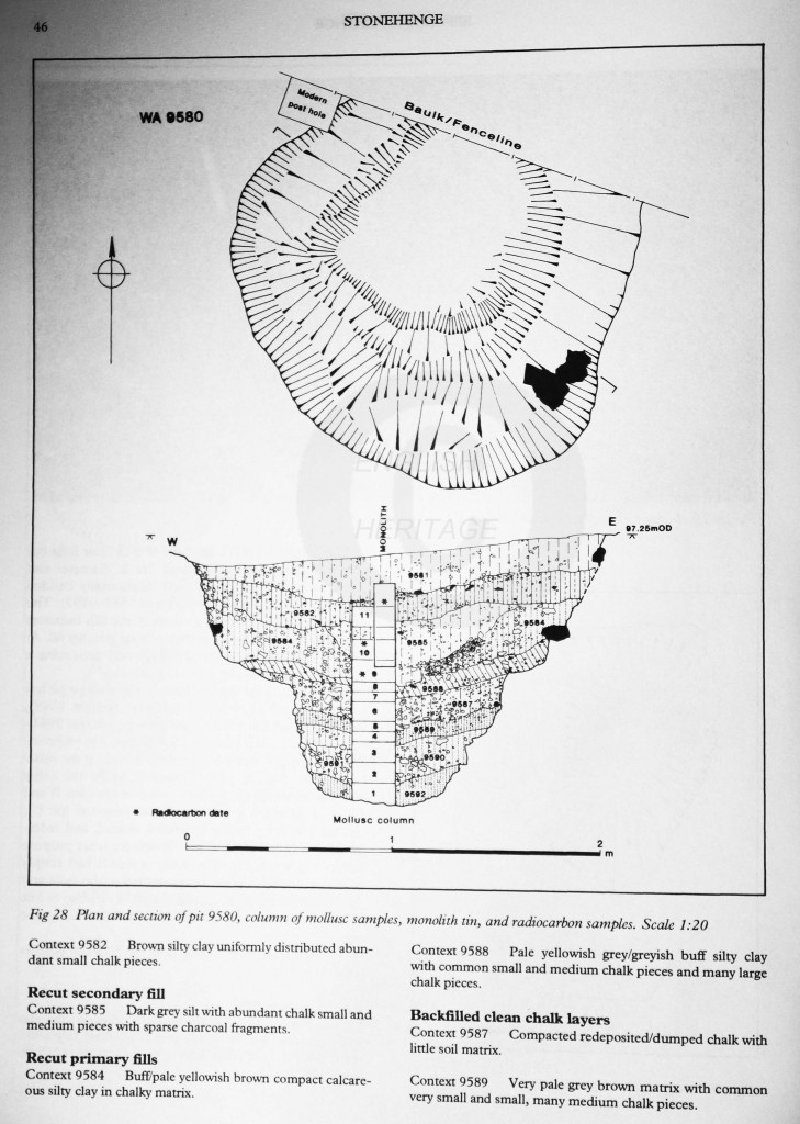
Mesolithic Post Holes Stonehenge Cross Section WA 9580 Copyright English Heritage
- English Heritage conclude this section on Mesolithic activity at Stonehenge on pages 55 and 56 of SIIL with “The three postpits excavated by the Vatchers contained definite evidence of having held large pine posts of 0.6- 0.8m which probably rotted ‘in situ’ or were removed when rotten. These therefore contained large upright pine timbers which must (as the excavators appreciated) by virtue of their spacing have stood without horizontal members spanning them…Pine timbers of this size would take about 70 years to grow, but could have lasted centuries once erected.The only other feature recorded by the Vatchers was interpreted as a treehole. Although this feature was less regular in plan than the others, the excavators did admit to the possibility that the ‘treehole’ was dug as a hole for a post and that the soft deeper deposits were subsequently exploited by trees or bushes. If the bottom of the treehole contained compacted chalk rubble, it is conceivable that this was unexcavated backfill mistaken for weathered chalk, in which case its broad plan and profile would mirror that of pit WA9580. If the treehole is accepted as a dug feature and all the car park features are broadly contemporaneous (which can not be confirmed on radiocarbon grounds) then there is evidence for a series of five pits, three of which certainly held pine posts or poles.This suggests a degree of planning, that is of conscious actions resulting in the erection of a related group of poles rather than the occurance of several pits, unassociated except in terms of their close proximity to one another.”
Michael Allen, who has worked on the natural archaeo-ecology of the site, suggests this Mesolithic landscape was open savannah or rough grassland, and preserved soil under the Cursus long barrow would never have supported ancient woodland. He proposes that the early landscape showed a number of ‘special’ places with open grassland, but with a mosaic of different vegetation nearby.
Since 2005, archaeological excavations have been underway on a Mesolithic settlement at Blick Mead in the northeast corner of Vespasian’s Camp in Amesbury, Wiltshire (NGR SUI 46417), 2km east of Stonehenge. The latest publication in respect of this ongoing insight into Mesolithic society in this part of Wiltshire and in Britain more generally is here. One of the key questions David Jacques asks in the discussion on page 22: “Is there evidence for the Neolithic ritual landscape of Stonehenge being a response to earlier activity?’ The earlier archaeologically dated activity at Blick Mead has established that it was a consistently used place for nearly 3000 years during the Mesolithic period. The advantages for people and animals at Blick Mead during the Mesolithic were:
- A spring with a water temperature at 10-13 degrees all year round.
- The spring is protected from the persistent and prevailing southwesterly wind, as it is located in the lee of a hill, a natural spur of chalk known as Vespasian’s Camp.
- The constant water temperature around the spring would have created an extended growing season.
- Wild fowl, eels, beavers, and varieties of fish were likely to have been abundant at the site.
- The site (as now) was likely to have been abundantly wooded in the Mesolithic, therefore rich in fuel and building materials.
- Being close to the Avon River would have enabled good communication with other communities such as at Downton (Eric Higgs 1959).
- Accessible supplies of flint nodules for toolmaking and raw materials for prestige tools were available here.
- The presence of rare algae along the springline such as Hildenbrandia Rivularis, which turns red oxidised flint a magenta pink when removed from the water. This phenomenon has not been recorded at any other archaeological site in the British Isles and is unique to Blick Mead.
- A migratory path for birds from mainland Europe into Britain is made along the Avon valley each Spring.
Intensely-fired burnt flint and the remains of aurochs, wild boar, and red deer evidence that hunting, butchery, cooking and food consumption took place at a base close to the spring. The cooking of salmon, trout and toad points as well to extended stays here. Huge community efforts would have been necessary to successfully hunt and kill aurochs and a single animal was sufficient to feed up to 100 people. All the stages of toolmaking are present at Blick Mead, alongside evidence of large-scale fires, hunting and eating.
The percentage of aurochs from the identified remains is the highest found nationally from a Mesolithic site. These animals:
- Were physically the most powerful in the landscape.
- Were twice the size of modern cattle.
- Ate prodigiously, therefore open places they occupied generally had lower levels of vegetation. They were the ‘vacuum cleaners’ of the Mesolithic.
- Are likely to have been ferocious, fast, and agile fighters, able to run up to 35 miles per hour.
Mike Allen observes that the area around Stonehenge in the early Mesolithic would have resembled open woodland and open country, being’ certainly…visible from higher ground such as Coneybury Hill and King Barrow Ridge, where concentrations of Mesolithic worked flint have indeed been found.
David Jacques further states:
“King Barrow Ridge slopes down to Stonehenge Bottom, which in Mesolithic and later times, may have had a water course draining close to Lake and then the River Avon. (Mark Bowden pers. comm). A fording point exists here where a natural funnel, possibly created by a paleochannel, forms a side valley and takes ones line of sight hundreds of metres westwards, directly to the area where the Mesolithic posts in Stonehenge car park were situated. This funnel, running straight from the fording point, could have potentially herded aurochs moving towards this open vista or, if they were coming the other way (west to east), in the direction of the ford. Long funnel shapes prevent cattle from seeing potential predators from the flanks and can create panic. Straight high-sided funnels used to be a standard part of abattoir design to increase cattle bunching and movement towards the area they would be killed…Rather than Mesolithic posts establishing a line of sight to Beacon Hill on the eastern horizon (Parker Pearson 2012 137), perhaps they were set up to mark the east-west movement of aurochs, and probably other large herbivores, through a relatively open landscape. Perhaps they functioned in part as ‘time’ markers to predict when the animals would be at certain places? These markers could have been seen from higher ground on the northern, eastern and western ridges encircling the Stonehenge landscape, but not the southern part. Viewed in this way, this part of the landscape would have been a place of advantage for hunting groups with long sight lines across the plain, a predictable side valley route where aurochs and other animals could be observed entering or departing the area, and places to hide. The likely water course at Stonehenge Bottom — at certain points in the year draining into the Avon — potentially provided a route back to the homebase to take the remains of large animals away.
The earliest radiocarbon date from Blick Mead makes it broadly contemporary with the 8th millennium BC Mesolithic post built monument 1.8km away at Stonehenge car park. We suggest that the posts should be seen as fixed points in the Mesolithic cultural landscape of the 8th – 7th millennia BC. At Blick Mead it is likely that we have found a locale used by people who made, placed and used the Stonehenge posts…The two places were possibly linked, as this was an unusually open part of Salisbury Plain, especially suitable for hunting. Both plain and spring may have become redolent with myths and traditions associating them with special, perhaps sacred, hunting grounds over a long period by hunter gatherer groups.
In addition to linking the earliest monumental structures at Stonehenge with Blick Mead, the radiocarbon dates also possibly connect later Mesolithic uses of the landscape with the construction of the first Neolithic monuments. The Coneybury Anomaly, a ceremonial pit and the earliest Neolithic site in the landscape (3950-3790cal BC…OxA-1402; Richards 1990) is situated on Coneybury Hill to the east of Stonehenge. It would have been intervisible with the western flank on Vespasian’s Camp, the River Avon, and the future site of Stonehenge. The “Anomaly’s” pit was filled with apparently structured deposits from a large butchery event, including wild and domesticated animal bone, charcoal, cereal grain, early Neolithic pottery and an assemblage of tools. Some of the material may have been chosen to evoke Mesolithic life paths, for example, the wild fauna, some of it directly associated with river valleys, such as beaver, and broad-blade tool types (the principal type found); while others project early Neolithic ones, for example, in the choices of cereal grain, domesticated fauna, pottery and tools, such as the two leaf-shaped arrowheads and the fragment of a polished stone axe. Rather than just viewing this deposit as debris from a large one-off party (Parker Pearson 2012, 24-25), perhaps it was deliberately chosen to signify different material cultures. The prominent location for this event on the high ridge is also suggestive of a high profile display; the amount of meat produced for the feast could have fed hundreds (ibid,25). Taken together, the assemblage from the Coneybury Anomaly, and the activities associated with it, seem to freeze-frame a transition between the late Mesolithic and early Neolithic in a way suggestive of a moment of cultural appropriation or assimilation.
The only radiocarbon date from the Coneybury Anomaly deposits suggest that this interchange was happening rather later than the period usually ascribed to the end of the Mesolithic, though Whittle et al. argue that the Neolithic did not begin in this part of Wessex until the 39th century BC (Whittle et al. 2010, 204). Interestingly, the later Coneybury ‘Henge’ enclosure monument was built close to this spot…It would have been intervisible with West Amesbury Henge and the River Avon to the southeast, Vespasian’s Camp to the east and the ditch and bluestone arrangement in the Phase One development of Stonehenge to the northwest.
Christie’s discovery of a pit containing pine charcoal at the western end of the Greater Cursus (Christie et al. 1963, 370-82) is also suggestive of Mesolithic activity incorporated into a relatively early Neolithic structure. Pine was part of the pre-boreal Stonehenge landscape and was absent in the area in the Neolithic (a radiocarbon date from this charcoal is required). The Greater Cursus is a monumental east-west raised inter-valley route which runs downslope across Stonehenge Bottom to reach the western terminus: both direction and topography parallel the suggested route taken by aurochs posited above. Thomas et al. (2009, 44) also wonder if the Greater Cursus might reflect earlier Mesolithic routes between the Avon and Till interfluves. Closer to Stonehenge, the Stonehenge Riverside Project recently discovered a Mesolithic hunting camp west of the site (Parker Pearson 2012, 234-236) with a hint of late Mesolithic to early Neolithic activity in the form of a bovine bone in the packing of Sarsen 27 at Stonehenge, radiocarbon dated 4340-3980 BC (Darvill 2005, 66). Of related interest is the wild animal bone curated with domestic cattle remains in the foundation deposits for the Phase One ditch at Stonehenge (Allen and Bayliss 1995, 511-535). Was an older symbolism attached to these different human animal lifeway choices? Again, as at the Coneybury Anomaly, wild and domestic seem to be chosen to be active signifiers.
Sharing the same river terrace with Blick Mead is the Mesolithic site west of Countess Farm. Wessex Archaeology’s report on the cache of 216 Mesolithic worked flints, plus 180 pieces of burnt flint (Leivers and Moore 2008 14-17), highlights the scarcity of late Mesolithic material in the area and the significance of the finds in those terms. There can be little doubt that this site is part of the same settlement nexus as Blick Mead.
Until now, earlier find spots have been described in isolation, but they can now be tentatively brought together with Blick Mead to reveal potential patterns of use in the landscape. The evidence suggests hunting groups foraying out from sheltered locales at Blick Mead up on the nearby ridge and the Plain in search of animals. Later Mesolithic occupation in the area seems particularly dense, especially if the sites from West Amesbury, Countess Farm, Blick Mead, and perhaps even the Coneybury Anomaly, are drawn together. There is also the possibility of transportation links with nearby sites like Downton and others further afield.
In conclusion, the Blick Mead discoveries are of great importance and the later Mesolithic may well emerge as a new starting point for the better-known archaeology of the Stonehenge landscape.”
– David Jacques ‘Mesolithic Settlement near Stonehenge : excavations at Blick Mead, Vespasian’s Camp, Amesbury.’ Published Wiltshire Archaeological and Natural History Magazine, vol 107 (2014),pp 7-27.
Richards (1990 263) cites the results of a sample excavation through a colluvial bench on the western side of the River Avon below Durrington Walls, which revealed an in situ blade-based flint industry with microliths. A hint of another possible locale is north of Blick Mead.
The late Mesolithic and earliest Neolithic times of approximately 5500-4000BC covers the transition from hunter-gatherer lifestyles to agricultural subsistence farming. Around 5000BC is generally accepted as the time of the first construction of monuments and the opening up of the environment. Finds in the Stonehenge environs dated to this time hint at connections with peoples from other regions, including a flake of Portland chert from outcrops on the south coast and a perforated dolerite pebble hammer found inside Durrington Walls, probably from the Welsh Marches. In January this year, it was announced that the latest radiocarbon dating on charcoal discovered at Blick mead last October dates back to 4,330 – 4246 BC. This provides a peer date to a find within the Stonehenge monument. OxA-4902 ‘ox-sized bone’ from the packing of stonehole 27, which has a radiocarbon date range attributed at 4350-3970BC. Although identified as an ‘ox-sized bone’, it could be an auroch bone, and a tentative link to the Mesolithic people who inhabited the Blick Mead site and the area later to become the site of the Stonehenge monument we know today, 2km to the west.
In 1957 Mr. Eric Higgs excavated another Mesolithic site in the Avon valley just outside the Stonehenge landscape at Castle Meadow, Moot Lane, Downton, south of Salisbury on a terrace of the River Avon, 140 feet O.D. and 25 feet above the present river. His findings were published on pages 209-232 of The Proceedings of the Prehistoric Society 25, 1959. An industrial Mesolithic flint assemblage was recorded at by-products of 37153 and Implements of 933, of late Mesolithic character. He observed that this industry exhibited characteristics well established in the North Sea area, Surrey, Sussex and the Thames valley and made specific comparisons to finds in Farnham (Surrey) Iwerne Minster (Dorset) and Peacehaven (Sussex).
Clear traces were found of a shelter or shelters in the form of stakes sharpened and ‘obviously’ intended to be driven into the ground. It was suggested the plan of the stake holes was indicative of a light, possibly summer, or temporary camp. Tree branches were likely to have been pulled together at the top and plaited to form a roof and walls. A hearth was found to the east of the excavation and southeast of the stake hole area. In all, 23 stake holes were discovered, averaging 4.25 inches in diameter. Two cooking holes were located within the stake hole area and a further two just to the southeast.
The Proceedings of the Hampshire Field Club and Archaeological Society, Vol. 27, for 1970, published Suzann Palmer’s excavation report on a Mesolithic camp approximately 20 miles further south on the banks of the Avon River at a point where it converges with the Stour River. The conjoined waters flow into Christchurch Harbour before discharging into the English Channel via ‘The Run’. The site is by the Stanpit Nature Reserve on Christchurch Harbour. Two hearths with large areas of burnt, concreted sand were found in trench 1. One hearth consisted of two slabs of Purbeck limestone and the other consisted of one big slab of limestone. Three large hearth stones, also of Purbeck limestone, were found in trench 2. Interestingly, four small artifacts made of Portland chert were found in trench 1: two waste flakes; one micro blade; and an oblique trimming flake from a tiny micro core. A total of 368 artifacts were found, as well as 5 hearths. Suzann Palmer concluded at the time:
- The Mother Sillers site appears to have been a camping site during the Mesolithic period, possibly after 5,000 BC, when the sea may have been a short distance from the site. Earlier sites on the ancient shoreline are now submerged.
- The stone industry is small, but the ratio of the various artifacts to each other is well balanced. The amount of waste far exceeds that of tools. This is consistent with the economy of wandering folk, staying for a short time in a favourable spot with an adequate supply of raw material.
- The slabs of Purbeck limestone for the hearths and the Portland chert artifacts are of particular interest as they indicate folk movement from west Dorset, possibly from the Isle of Purbeck in the case of the hearth stones, and from the Isle of Portland or the Fleet. The nearest source of Purbeck limestone to Mother Sillers Channel is a walking distance of approximately 15 miles. It is difficult to explain why fairly heavy stone slabs were carried this distance, except perhaps for the fact that the stones from the Eocene beds of the Christchurch area are inclined to crack apart rather quickly when subjected to heat. Tranchet axes were made and used by the Mesolithic coastal dwellers.
- The microliths include geometrical forms.
- This group consisted of around fifteen individuals, i.e. at least three per hearth.
The fact that 20 Portland chert artifacts had been found in the area local to this excavation, up to the time of writing, resulted in Suzann Palmer also observing: “The evidence suggests connections with the prolific Mesolithic industries on the Isle of Portland. Small bands of folk apparently wandered far and wide along the coast and inland along the rivers”. The fact that Portland chert has also been found in the Stonehenge landscape begs the question of whether the coastal Mesolithic peoples would have had contact with those at Blick Mead, using the Avon valley and River Avon as a Mesolithic highway of communication. The mouth of the River Avon at Christchurch Harbour and Hengistbury Head is likely to have been an important locale in the distribution of ideas and materials from the coastal dwelling Mesolithic people to those living further inland and possibly 33 miles further north in the Avon valley in the hunting grounds around Blick Mead, where year-round food supplies provided a stabilising influence on the settlement pattern in that area.
Returning to the site of the Stonehenge monument itself, radiocarbon dating samples older than stage 1 are kindly summarised here by Mr M. Pitts. Five separate items are identified as ‘Ox’ bones, including the curated ox skull from the terminal southwest entrance discovered by Lt.-Col W. Hawley during his 1920s excavations. Inigo Jones, who ‘digged throughout all the foundations’ at Stonehenge, observed that he had discovered ‘Bulls and Oxen and several sorts of beasts’.I attended a lecture at Antrobus House Amesbury on 7 November by Davis Jacques the Mesolithic archaeologist who offered the suggestion that some of these skulls and bones may be mis identified as Oxrn and may be of of Auroch .
Earlier Neolithic long barrows in the vicinity of Stonehenge often included ox skulls and bones:
- The mortuary house at Fussells Lodge included an ox hide complete with an ox skull draped over it.
- Two complete ox skulls were found at Tilstead Lodge barrow
- William Cunnington discovered ‘a huge skull’ at Knook 2
As Aubrey Burl observed in The Stonehenge People: “The rituals inside Stonehenge …corresponded to the funerary activities of earlier Neolithic people at their long barrows …The discovery of Ox skulls at Stonehenge makes it likely that rituals of death were performed there also”.
These later activities perhaps echoed the beliefs of the Mesolithic hunters based at Blick Mead who used the landscape that was to become Stonehenge as their hunting grounds for aurochs and other animals and erected the first monument in the Stonehenge landscape ten thousand years ago.
Car park post holes Stonehenge
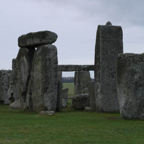
Stonehenge 16 January 2015

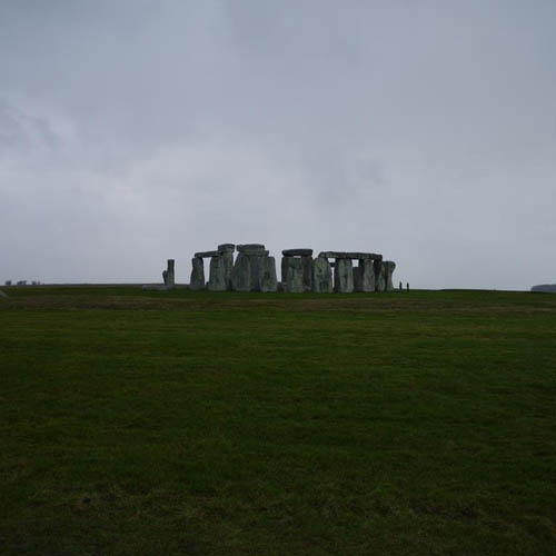
Stonehenge landscape
Thank you to English Heritage for kind permission to reproduce the Car park Mesolithic post hole location map and cross section images above, and to Aynslie Hanna and Colin Wheeler .